The shift isn't cosmetic. The Utah Department of Transportation reported in 2024 that it was among the first agencies in the nation to deploy operational LiDAR safety software at live intersections, backed by a $20 million federal grant. That's not a pilot program buried in an academic paper — it's production infrastructure.
This guide breaks down what LiDAR traffic detection actually is, how it works stage by stage, and where agencies and contractors are putting it to use today.
Key Takeaways
- LiDAR uses laser pulses to build real-time 3D maps, detecting vehicles, cyclists, and pedestrians without cameras
- It performs consistently in low light and most weather conditions, unlike camera-based systems
- Detection runs through four stages: initiation, point-cloud generation, calibration, and controller output
- Common applications include adaptive signal actuation, pedestrian crossings, and near-miss safety analytics
- Choosing the right configuration depends on intersection geometry, so agencies often consult experienced regional distributors
What Is LiDAR Traffic Detection?
LiDAR (Light Detection and Ranging) traffic detection uses pulsed laser beams to measure the distance, speed, and shape of objects on a roadway. The sensor emits thousands of laser pulses per second and measures how long each pulse takes to bounce back. That data builds a 3D point cloud: a live digital rendering of everything moving through the intersection.
This technology exists to close gaps that older detection methods couldn't solve. Inductive loops buried in pavement struggle to distinguish a bicycle from a motorcycle. Basic cameras lose accuracy in glare, fog, or full darkness. LiDAR was adopted specifically because it delivers multimodal classification (vehicles, cyclists, and pedestrians) without depending on ambient light.
What LiDAR Is Not
A few common mix-ups are worth clearing up:
- It's not a camera system. LiDAR captures spatial data points, not images or video, which matters for agencies navigating privacy regulations.
- Radar works differently. It uses radio waves to detect presence and speed, while LiDAR uses light pulses to generate precise 3D geometry, including shape and trajectory.
- Cost is a real tradeoff. Higher upfront investment than loops or radar exists, and agencies weigh that against classification accuracy gains.
Rotating vs. Directional Sensors
Traffic LiDAR generally comes in two configurations:
- Rotating (360°) LiDAR — a single unit mounted centrally can cover an entire intersection, useful where pole placement allows a clear, unobstructed view of all approaches.
- Flash/fixed LiDAR — directional units aimed at specific approaches, often deployed in multiples per intersection to cover complex geometries or avoid occlusion from trucks and turning traffic.
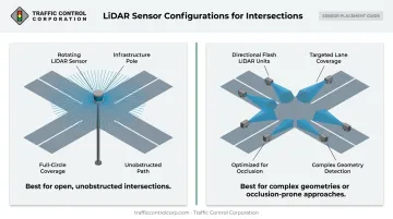
The right choice depends on lane count, approach angles, and existing pole infrastructure — which is exactly why agencies often loop in a distributor like TCC before locking in a spec.
How Does LiDAR Traffic Detection Work?
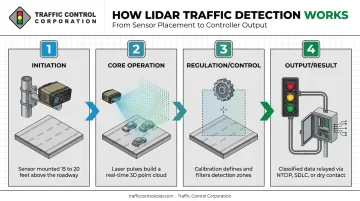
LiDAR detection isn't triggered manually. It runs as a continuous sequence: emission, mapping, calibration, and controller output. Each stage feeds directly into how the traffic signal ultimately responds.
Initiation
Detection begins the moment the sensor is powered and mounted, typically 15–20 feet high on a traffic pole or mast arm. There's no start button — it runs continuously, scanning its field of view around the clock.
Installation, not the sensor itself, causes the most common bottleneck at this stage. Mounting height or angle that deviates from manufacturer specs can create blind spots, leading to undercounting before the system ever processes a single vehicle. Getting this right the first time matters more than most agencies expect.
Core Operation
Once running, the sensor emits thousands of laser pulses per second and measures time-of-flight (how long each pulse takes to return) along with reflectivity. That combination calculates the exact distance and position of every object in range.
These individual points combine into a real-time 3D point cloud, capturing every vehicle, cyclist, and pedestrian within the sensor's field of view, which commonly spans 120° to 360° depending on the unit.
Accuracy here isn't uniform across use cases. NCHRP validation research found motorized-traffic counting accuracy (WMAPE) ranging from 1.5% to 8.4%, with correlation scores between 0.99 and 1.00, indicating strong agreement. Temporary nonmotorized counting setups, by contrast, showed WMAPE as high as 44.9% to 54.5%.
Point density and channel count directly affect precision, which is why permanent, properly configured installations outperform temporary ones by a wide margin.
Regulation / Control
Raw point-cloud data means nothing without calibration. This stage defines detection zones, filters sensitivity, and configures the sensor to tell a delivery truck apart from a pedestrian standing at the curb.
Recalibration matters more than agencies often assume. Dirt buildup, sensor drift, and extreme weather all degrade accuracy over time. Common failure points include:
- Occlusion from large vehicles blocking smaller road users
- Dark or low-reflectivity objects that return weaker signals
- Reflective surfaces or debris that create false positives
- Incorrect zone boundaries left over from initial setup
Periodic validation against manual counts remains the recommended practice for catching drift before it becomes a costly miscount problem.
Output / Result
The end product is classified, real-time data (vehicle counts, speeds, occupancy, and road user type) transmitted to the traffic signal controller. This typically happens through one of three interfaces: NTCIP, SDLC, or dry-contact protocols, each representing a different layer of the controller-cabinet architecture.
Controllers use this output to actuate signal phases, extend green times, or trigger pedestrian walk signals in real time. Consistent, accurate data at this stage translates directly into fewer unnecessary stops, reduced congestion, and measurable safety gains at the intersection.
Where Is LiDAR Traffic Detection Used?
LiDAR shows up across several operational contexts:
- Signalized intersection actuation — feeding real-time vehicle and pedestrian data to extend or shorten signal phases
- Highway speed and volume monitoring — tracking corridor-level traffic patterns
- School zones and pedestrian crossings — where vulnerable road user detection carries higher stakes
- Safety analytics — near-miss detection, red-light-running analysis, and wrong-way driving alerts
LiDAR performs best in:
- Dense, multimodal intersections with mixed vehicle, bike, and pedestrian traffic
- Low-light or high-glare corridors where camera systems struggle
- Locations with privacy regulations limiting camera-based detection, since LiDAR never captures identifiable images
Getting the deployment right starts with hardware selection. Choosing between a single 360° unit and multiple directional sensors depends heavily on intersection geometry — lane count, approach angles, and existing pole placement all factor in. Misapplying the wrong configuration is a real and costly mistake, which is why working with an experienced local distributor pays off before equipment gets ordered.
As the leading Midwest distributor of traffic signal equipment and ITS solutions for over 75 years, Traffic Control Corporation (TCC) helps state DOTs, municipalities, and contractors across its 11-state territory select, source, and support detection technology. This includes the Ouster LiDAR and BlueCity platform, distributed through Econolite, along with real-time 3D point-cloud modeling and integration with Econolite Cobalt ATC controllers.
Factory-trained field service rounds out the offering, covering onsite troubleshooting and commissioning after installation.
LiDAR vs. Other Traffic Detection Technologies
Every detection technology makes trade-offs. Here's how LiDAR stacks up against the alternatives on the factors that matter most:
| Factor | LiDAR | Radar | Inductive Loops | Cameras |
|---|---|---|---|---|
| Weather/lighting reliability | Strong; heavy snow/fog can reduce range | Strong in most conditions | Unaffected by weather | Degrades in glare, fog, night |
| Classification accuracy | High — vehicles, cyclists, pedestrians, trajectories | Good for presence/speed, less shape detail | Presence/count only, no classification | Good visual detail, weak in occlusion |
| Privacy/data handling | No images captured | No images captured | No images captured | Captures video/images |
Installation is another major differentiator. LiDAR's pole-mounted, non-invasive install offers clear advantages over loop-based detection:
- Avoids pavement cutting entirely, since sensors mount on existing poles
- Eliminates the extended lane closures that loop installation requires
- Reduces the safety risk that work-zone closures create on high-volume corridors
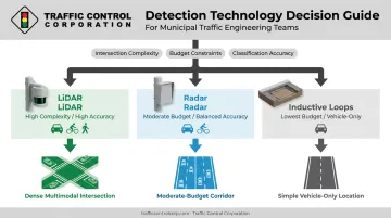
That said, no single technology wins every scenario. Many agencies run a mix, pairing LiDAR at complex multimodal intersections with radar or loops at simpler locations where budget matters more than granular classification. Vendor-neutral guidance, rather than a one-size-fits-all pitch, tends to produce better long-term outcomes for the agency footing the bill.
Conclusion
LiDAR traffic detection converts laser pulses into precise, real-time 3D data. Traffic systems use that data to make smarter, safer signal decisions at intersections where the margin for error is thin. Understanding that process, from initiation through controller output, puts agencies in a stronger position to ask the right questions during procurement.
That procurement process is where TCC's expertise adds value. Decades of Midwest experience and access to 40+ manufacturers give agencies and contractors a practical path to choosing and implementing the right LiDAR-based detection solution for their specific intersection or corridor.
Frequently Asked Questions
How accurate is LiDAR for detecting vehicle speed?
LiDAR calculates speed by measuring the change in an object's position across successive laser scans. Validated research shows motorized-traffic counting accuracy (WMAPE) as tight as 1.5% to 8.4% in tested configurations.
Can LiDAR detect traffic lights or read their signals?
No. LiDAR sensors detect vehicles, pedestrians, and objects, but they don't read signal head colors. That function typically falls to separate camera-based systems, while LiDAR feeds its own detection data to the controller.
How far away can LiDAR detect traffic?
Range varies by model rather than following one universal figure. Some units reach 30–75 meters depending on configuration, while higher-resolution sensors reach up to 120 meters at strong reflectivity levels.
Is LiDAR traffic detection affected by weather conditions?
LiDAR performs well in most rain, fog, and low-light conditions since it doesn't rely on ambient lighting. Heavy blowing snow or fog with visibility under 20 feet can scatter laser signals and reduce effective range.
How does LiDAR compare to radar and inductive loops for traffic detection?
LiDAR offers superior classification and 3D spatial accuracy compared to radar's simpler presence-and-speed detection. Inductive loops require invasive pavement installation and cover a more limited detection zone than either sensor type.
How much does LiDAR traffic detection cost to install and maintain?
LiDAR sensors typically carry a higher upfront cost than loops or radar, but non-invasive, pole-mounted installation often lowers long-term maintenance costs. Traffic Control Corporation, as a regional distributor serving Midwest agencies, can provide application-specific quotes based on your intersection's geometry.