Introduction
Dense urban intersections handle cars, trucks, cyclists, pedestrians, and micromobility users simultaneously — often in low light, rain, or Midwest winter conditions. Traffic detection systems that fail under these demands don't just create inefficiencies. They create safety gaps.
The problem with legacy detection is spatial. Inductive loops confirm a vehicle is present but tell you nothing about what it is, where it's headed, or whether a pedestrian is waiting nearby. Video cameras deliver rich visual data until clouds roll in, headlights create glare, or a shadow falls across the detection zone. Research from the Utah DOT found video detection systems dropped from 87.2% correct calls during daylight to 73.4% at night and 81.3% in adverse weather.
3D LiDAR object detection addresses these limitations by generating its own light, measuring space in three dimensions, and maintaining consistent performance across lighting conditions and weather. It doesn't rely on ambient light or visual contrast — which is precisely why transportation agencies are deploying it where other sensors fall short.
This guide explains how the technology works, where it fits within traffic infrastructure, and what agencies should evaluate before committing to deployment.
Key Takeaways
- 3D LiDAR uses laser pulses to build precise point clouds that identify objects by position, size, speed, and trajectory
- Unlike cameras, it operates reliably in low light, rain, fog, and snow
- Detects and classifies vehicles, pedestrians, cyclists, and scooters simultaneously
- Applications include signal control, pedestrian detection, traffic data collection, and V2X infrastructure support
- Deployment success requires matching sensor capabilities, placement geometry, and integration needs to each site
What Is 3D LiDAR Object Detection?
3D LiDAR object detection is a sensing process in which a LiDAR (Light Detection and Ranging) sensor emits rapid laser pulses and measures the time each pulse takes to return after hitting a surface. That timing data constructs a three-dimensional point cloud, a spatial map of every object within the sensor's field of view.
The "3D" Distinction
The three-dimensional part matters significantly in traffic applications. Inductive loop detectors and basic video systems capture planar, two-dimensional data. They can tell you something is present, but not much more.
3D LiDAR captures X, Y, and Z coordinates simultaneously for every return point. That means each detected object carries:
- Height, width, and depth — enabling accurate size profiling
- Position and orientation — showing where an object is and which direction it faces
- Trajectory — tracking movement frame by frame
That geometric richness allows 3D LiDAR to classify object types — cyclist vs. pedestrian, bus vs. passenger car — without relying on image recognition or ambient lighting conditions.
Deployment Context for This Guide
Understanding what 3D LiDAR captures naturally raises the question of where it's deployed. The technology appears in two main settings: roadside-mounted sensors for intersection and corridor detection, and vehicle-mounted sensors for connected and autonomous vehicle systems.
This guide focuses on roadside infrastructure applications — the context most relevant to state and local transportation agencies managing signalized intersections and arterial corridors.
3D LiDAR vs. Traditional Traffic Detection Methods
For traffic engineers and agency decision-makers, the question isn't whether 3D LiDAR is technically impressive — it's whether it solves problems your current detection can't. Here's how the technologies compare.
Inductive Loop Detectors
Loops detect vehicle presence through electromagnetic response. They work for basic vehicle actuation, but carry significant operational limitations:
- No information on object type, height, speed trajectory, or pedestrian presence
- Maintenance-intensive: FHWA data shows 25% of New York loops were inoperative at any given time, with annual failure rates of 24% in Minnesota and 29% in Cincinnati
- Installation and repair require lane closures; sawcut slots can weaken pavement over time
Video-Based Detection
Cameras provide object classification and visual context — but performance degrades under conditions that are routine in the Midwest:
- Night, glare, shadows, precipitation, and occlusion all affect detection accuracy
- Depth estimation requires additional processing, adding latency and error
- Lens contamination from road spray or ice reduces reliability in winter months
Radar Detection
Radar offers weather resilience and velocity measurement, making it a solid choice for speed enforcement and basic presence detection. However, it supplies sparser geometric information than 3D LiDAR. Radar returns speed and approximate position; 3D LiDAR returns a detailed surface map of the object — including height, volume, and shape.
3D LiDAR: Where It Stands Out
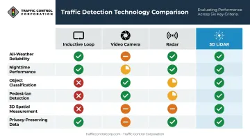
Taken together, here's how the four technologies stack up across the capabilities that matter most for modern intersection management.
| Capability | Inductive Loop | Video Camera | Radar | 3D LiDAR |
|---|---|---|---|---|
| All-weather reliability | ✓ | Limited | ✓ | ✓ |
| Nighttime performance | ✓ | Limited | ✓ | ✓ |
| Object classification | ✗ | Partial | Limited | ✓ |
| Pedestrian detection | ✗ | Partial | Limited | ✓ |
| 3D spatial measurement | ✗ | ✗ | ✗ | ✓ |
| Privacy-preserving data | ✓ | ✗ | ✓ | ✓ |
A 2023 roadside evaluation published in PMC reported 98.2% multi-object tracking accuracy (MOTA) for a LiDAR-based tracker over 1,000 frames — though results vary by algorithm and site conditions and shouldn't be treated as a universal performance guarantee.
How 3D LiDAR Object Detection Works
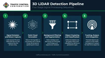
Understanding the detection pipeline helps agencies ask better questions during procurement and set realistic expectations at each stage.
Step 1 – Signal Emission and Return Capture
The sensor emits laser pulses across its field of view — either a full 360° horizontal sweep or a defined detection zone. Each pulse travels until it hits a surface, then returns to the sensor. The time elapsed between emission and return (time-of-flight) is converted into a precise distance measurement for that point.
Step 2 – Point Cloud Generation
Thousands of these distance measurements compile every second into a point cloud: a three-dimensional map where each point carries X, Y, and Z coordinates plus return intensity. Sensors with more channels (32, 64, or 128) produce denser vertical sampling, which improves detection of smaller or more distant objects. Higher channel counts don't guarantee better accuracy on their own. Point density at the detection zone boundary, scan rate, and algorithm quality carry just as much weight.
Step 3 – Background Filtering and Segmentation
Before any object detection happens, the system establishes a static background model from repeated scans : road surface, signal poles, guardrails, buildings. Incoming point clouds are compared against this reference, and only new or moving objects are flagged for processing. This step dramatically reduces computational load and keeps real-time performance viable.
Step 4 – Object Clustering and Classification
Foreground points are grouped into clusters based on spatial proximity. Each cluster is then analyzed for geometric properties:
- Height and width — is this a pedestrian or a truck?
- Length and shape — does the profile match a bicycle or a sedan?
- 3D bounding box — a precise spatial boundary assigned to each detected object
This geometric classification is where 3D LiDAR separates itself from loop detectors and basic radar.
Step 5 – Tracking, Output, and Integration
The system tracks classified objects frame to frame using trajectory prediction models, anticipating position in the next scan cycle based on current velocity and direction. Output is structured and immediate:
- Object type (pedestrian, bicycle, vehicle class)
- Position and speed (real-time coordinates and velocity)
- Heading (direction of travel)
This data feeds directly into traffic signal controllers, traffic management center (TMC) software, or connected vehicle platforms for real-time decision-making.
Key Applications of 3D LiDAR in Traffic Infrastructure
3D LiDAR isn't a single-use sensor. It serves multiple functions across intersection management, corridor monitoring, and emerging connected transportation systems.
Intersection Detection and Signal Control
Roadside-mounted 3D LiDAR enables simultaneous detection across all approach lanes, including lanes where inductive loops were never installed or have since failed. Practical capabilities include:
- Queue length measurement for adaptive signal timing
- Detection of vehicles in all lanes during all weather and lighting conditions
- Red-light running identification for post-hoc safety analysis
- Support for trajectory-based signal control strategies
A USDOT ITS Knowledge Resources entry on a Colorado Springs deployment found that trajectory-based control reduced total intersection delay by 15.8% to 23.7% compared to coordinated control — though the full result reflects the complete system, not LiDAR hardware alone.
Pedestrian and Vulnerable Road User Detection
NHTSA reported 7,314 pedestrian deaths in 2023, and IIHS counted 1,155 bicyclist fatalities the same year. These numbers underscore why detection systems must cover vulnerable road users, not just motor vehicles.
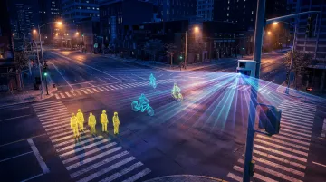
3D LiDAR detects pedestrians, cyclists, and micromobility users based on geometric profile and movement characteristics, even in darkness or precipitation. This enables:
- Pedestrian-actuated signal calls triggered by actual presence
- Protected crossing phases with reliable detection
- Near-miss identification for safety program evaluation
Traffic Volume, Classification, and Speed Data Collection
3D LiDAR functions as a continuous, high-accuracy traffic counting and classification platform. It produces:
- Vehicle classification by type (passenger car, SUV, truck, bus, motorcycle)
- Speed measurements across all lanes simultaneously
- Turning movement counts without manual observation or pavement sensors
For agencies pursuing grant funding, performance-based reporting, or planning studies, this data stream replaces periodic manual counts with continuous, automated collection.
Connected and Autonomous Vehicle Infrastructure Support
That continuous data stream also feeds into something larger: connected transportation infrastructure. Roadside 3D LiDAR plays a growing role in V2X (vehicle-to-infrastructure) environments, where sensors positioned at intersections broadcast real-time object data directly to connected vehicles.
This supports cooperative intersection management, wrong-way vehicle alerts, and work zone awareness. For agencies in TCC's Midwest territory beginning to plan V2X deployments, roadside sensing infrastructure already in place reduces the integration work required at go-live.
Challenges and Limitations Before Deployment
3D LiDAR offers clear performance advantages, but deployment requires honest planning around several practical constraints.
Sensor Placement and Coverage Geometry
The height, angle, and mounting position of each sensor directly affects detection coverage, occlusion risk (objects hidden behind buses or large trucks), and effective range. Complex intersections with heavy truck traffic or multiple approach lanes often require multiple sensors with overlapping coverage zones. There's no universal mounting height that works everywhere.
Occlusion and Scene Complexity
Dense queues, tall vehicles, and turning movements create shadows in the point cloud. Careful site analysis before procurement — not after — reduces the chance of discovering blind spots post-installation.
Cost and Integration Requirements
3D LiDAR systems carry higher upfront hardware and integration costs than loop detectors or basic radar. Successful deployment also requires:
- Compatibility verification with existing signal controllers
- Calibration at installation and periodic recalibration over time
- Edge computing hardware or network bandwidth for data processing
- Ongoing technical support from a vendor who understands your infrastructure
Weather Performance Expectations
While 3D LiDAR is far less affected by lighting conditions than cameras, heavy precipitation can reduce effective detection range. Manufacturer claims of all-weather operation should be validated through site-specific testing, not assumed.
How TCC Can Help
Traffic Control Corporation (TCC) has served Midwest transportation agencies for over 75 years as a B2B distributor of traffic signal products and ITS solutions. With branch offices across Illinois, Indiana, Missouri, Minnesota, and Iowa, and coverage spanning 11 states, TCC is positioned to support agencies evaluating and deploying 3D LiDAR detection from initial scoping through long-term support.
TCC distributes the Econolite Ouster LiDAR system as part of its detection technology portfolio, alongside the Econolite controller ecosystem (Cobalt, 2070LX+, ASC/3) and the Centracs ATMS platform that many Midwest agencies already run.
Econolite's open-architecture controllers support up to 120 detection inputs — enough headroom to integrate LiDAR alongside existing detection without replacing entire cabinet assemblies.
TCC's factory-trained and certified technical field service team provides:
- Product selection and application assistance — matching sensor capabilities to your intersection geometry and detection requirements
- Detection system commissioning — hands-on turn-on service at deployment
- Onsite troubleshooting — rapid field response for post-deployment issues
- Detection system audits and health checks — performance verification over time
- Product training — available at TCC's Woodridge, IL facility or on-site at your location
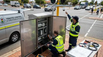
With a multi-million dollar inventory and representation of 40+ manufacturers, TCC gives agencies quick access to detection products backed by local technical support. Call TCC at 630-543-1300 or reach out to your regional field rep to work through your intersection or corridor detection requirements.
Frequently Asked Questions
What is the difference between 2D and 3D LiDAR object detection?
2D LiDAR scans a single horizontal plane and measures presence and distance along that plane only. 3D LiDAR captures multiple elevation angles simultaneously, producing full volumetric point clouds with height and depth — enabling object classification, size measurement, and multi-class detection that 2D scanning cannot support.
How does 3D LiDAR perform in adverse weather like snow, fog, or rain?
3D LiDAR generates its own laser light source and is far less affected by lighting conditions than cameras. Heavy precipitation can reduce effective range, though traffic-grade sensors are built with weather resilience in mind. Site-specific winter and nighttime testing remains the most reliable way to validate performance before deployment.
What types of objects can 3D LiDAR sensors detect in a traffic environment?
3D LiDAR systems classify objects by geometric profile — detecting and differentiating passenger cars, SUVs, trucks, buses, motorcycles, pedestrians, cyclists, and micromobility users. This multi-class capability is one of its primary advantages over inductive loops and basic radar, which offer limited or no object-type differentiation.
Can 3D LiDAR detection integrate with existing traffic signal controllers?
Many systems output data in formats compatible with NTCIP standards (such as NTCIP 1202 and 1209) or provide direct controller inputs. Compatibility is not automatic. Agencies should verify implemented NTCIP objects, detector-call mapping, controller firmware version, and any gateway requirements during procurement, not after.
How is 3D LiDAR different from radar for traffic detection?
Both technologies operate in adverse weather, but they differ in data quality. Radar measures speed and approximate presence; 3D LiDAR provides precise position, object geometry, classification, and trajectory — giving signal controllers and TMC platforms far richer situational awareness at complex intersections.
What should agencies evaluate when selecting a 3D LiDAR detection system?
Key evaluation criteria include:
- Detection range and coverage zone relative to intersection geometry
- Object classification accuracy across vehicle types and vulnerable road users
- Weather performance, validated through field testing
- Controller and ATMS integration compatibility
- Total cost of ownership (hardware, installation, calibration, ongoing support)
- Local technical support availability